Strengthen the capacity of Rwandese researchers and stakeholders to prevent and mitigate the impacts of floods and landslides on the local communities
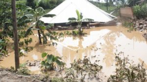
Rwanda is often affected by severe cases of landslides and floods. It is also one of the highest populated areas of the world. This context of strong demographic pressure has led to significant land use / land cover (LULC) changes which are likely the cause of an increase in landslide and flood occurrences, particularly in the mountainous regions of NW Rwanda near the Volcanoes National Park. Nonetheless, the impacts of LULC and its changes on the occurrence of these natural hazards remain difficult to predict and quantify. As a result, the development of suitable land management strategies (striking a balance between minimizing the impacts of these hazards and the high population pressure) remains highly challenging. This is especially so in the light of climate change.
This project therefore aims to study the effects of LULC and its changes over the past 60 years on the magnitude and frequency of landslides and floods, as well as the impacts of these hazards on the population. Our research will focus on two river basins in NW Rwanda with similar topographic and climatic characteristics but very different levels of LULC change. The expected results of this research are improved insights of the physical and anthropogenic factors controlling these two hazards and a better understanding of the population vulnerability facing these hazards. The outcomes of the project will be (1) an increased research capacity to conduct scientific risk assessment, integrating specific hydrogeomorphic hazards and associated risks with the human dimensions of risks; (2) the ability to make up-to-date assessments of these two hydrogeomorphic hazards which will be used to raise awareness and identify suitable mitigation and resilience strategies with exposed communities and all relevant stakeholders involved in disaster risk reduction; (3) a strong partnership from the beginning of the project with local and national stakeholders involved in disaster risk reduction, for a better integration of scientific insights into natural hazard and risk management policy.
Target Groups :
- INES: by strengthening the research and teaching capacities of its lecturers in hazard and risk management. This will be done by training of 3 PhD candidates on related subjects. INES professors will be prioritized as potential PhD candidates. 1 MSc student will also be selected from INES tutorial assistants
- University of Rwanda (UR) and Rwanda-Polytechnics: who will strengthen their research capacity and (inter-)national research network. This will be mainly done by contributing to the planned research and development activities as well as through their involvement in the supervision of the PhD candidates. 2 MSc students will be selected from UR and Rwanda-polytechnics tutorial assistants
- The north partners: 3 MSc students will be selected among the north partners to conduct their research oriented to the project and this project will also allow north partners to strengthen their research capacities in a new context.
- The Ministry of the Environment and its institutions (Rwanda Environment Management Authority (REMA), Meteo Rwanda and Rwanda Water and Forest Authority (RWFA)): through their direct involvement in the project, they will directly benefit from the research work carried out in the project as well as from the established collaborations.
- The Ministry in charge of Emergency Management (MINEMA): Professionals working in the ministry will actively participate in national workshops organised through the project.
Final beneficiary :
- The Students from INES, University of Rwanda and Rwanda-Polytechnics: they will benefit from a better education and training on the issues addressed in this project through the improved courses, research and teaching capacity that will result from this project.
- The Ministry of the Environment and its institutions: the research results of this project (e.g. data collected, hazard and risk maps produced) will be useful for their administration and contribute to better land management and more efficient landslide and flood disaster risk reduction strategies.
- The Ministry in charge of Emergency Management: Professionals working in the ministry will use tools and strategies designed for landslide and flood hazards management and disaster risk reduction.
- The Ministry of Infrastructure and its institutions like Rwanda Housing Authority (RHA) and Rwanda Transport Development Agency (RTDA): the designed tools will be useful to better design hydraulic structures.
- The Ministry of Agriculture and its institution like Rwanda Agriculture Board (RAB): the designed tools and disaster risk reduction strategies will be useful in agriculture sector.
- The Ministry of Local Government and the population living in landslide and flood prone areas: they will benefit from a lower exposure to these hazards and an increased resilience through the better land management and disaster risk reduction strategies that may be developed as an outcome of this project.